|
Dr. Arthur G. Tracey patent/tract index and map
locations for
Carroll, Frederick, and Washington Counties
an ebook edition of the original
microfilm prepared by
Dr. Edward C. Papenfuse and Sarah
Patterson
Maryland State Archives, October
2009
|
For the benefit of researchers wishing to locate the original
land grants (patents) in Washington County, the Carroll County
Historical Society deposited two
reels of microfilm with the Washington County Circuit Court. The first
reel contained an index to land grants (patents) in Carroll,
Frederick, and Washington counties that were keyed to maps created
and annotated by Dr. Arthur G. Tracey on the second reel of
film. This is an ebook edition of those two reels of film
with an introduction on its use.
1) Index Cards to Land
Patents of Carroll, Frederick, and Washington Counties-
Showing their location on
the land- their adjoining tracts-the relationship to one
another-plus other useful
information concerning them.
Reel msa_scm13085 (which
begins
here and ends here-a
total of 277
images).
Index cards alphabetical
by Tract name. Generally they all give:
name of tract
name of owner
county
date of survey/resurvey
date of patent
acreage
patent record citation
neighboring tracts
CFW map coordinates of Tracey gridded maps (images 40-101)
Certificate number
Sheet number (aka page number) of Tracey maps (images 257-854 in eBook)
Some index cards give additional information:
name of surveyor
district number
2) Land Patents of
Washington County, MD. Showing their location on the land-their
adjoining tracts- the
relationship one to another-plus other related information.
Reel msa_scm13086 (begins
here
and ends here-a
total of
898 images)
There may be
three or four shots of each map or part of a map, all of varying
lighting.
surveyed land and grid
maps of Washington County with the tracts mapped out.
Comparative drawings of
Tracey’s maps with previous maps of the area.
Land
Grants & Surveys.” Map and listing of Patent Names.
Gridded maps of
tracts. “Sheet” numbers listed, but they do not seem to match with what
is on the
cards.
Images 216-257:
Typed Lists/Histories:
IMG 216: File B-8, ENV #4:
“Indian
References Washington Co.,”
Shenandoah
IMG 221: File C-8, Envelope #4: “
CFW Roads, Ferries,
Fords, Etc., as taken
IMG 240: File C-8, ENV #4:
Prince George and
Frederick County Rent Rolls
IMG 251: File C-8, ENV #4:
“History of Frederick
County—Williams”
IMG 254: File B-8, ENV #4:
“Copy of the History of
the Lemen Family in the
IMG 255: File B-8, ENV #4:
“The Town of Maidstone and Watkins Ferry”
IMG 257: File B-8, ENV #3:
“Early Mills of Washington County”
Images 257-854:
Drawings and descriptions of tracts. These are the “sheets” referred to
in the index cards.
Images 855-893:
Variety of maps showing waterways and their origins
Images 894-898:
“Title” pages ending the reel
To use both reels of film now presented here as on-line images in an
ebook format,
the
user should first look for the tract/patent of interest in the index
cards
on the first reel. These index cards are hand written and are
in alphabetical
order by tract/patent name. They contain referencing coding related to
the
maps on the second reel of film which is explained below. When the
maps on the second reel were filmed, they were captured a number
of times at
different light settings to make them as legible as possible on the
microfilm reader and reader printers of the day. That means that the
ebook of map images may contain several images of each map. While the
index
card film was in fair condition, the map film
had been heavily used prior to scanning and poorly filmed. The images
reproduced here
are the best that can be obtained from the surviving film. If
resources permit they will be replaced over time by scans of the
originals.
Note that the jump script at the top of each of the ebook page can be
used to move quickly around within the ebook, but not from ebook to
ebook.
Dr. Tracey's tract index:
Dr. Tracey, who began his work in 1943, used published topographical
maps to which he added his own grid/coordinate system to
place
the tracts described on his index cards. Generally, his
horizontal grid was
numeric and his vertical grid was alphabetical. For example
this
card:
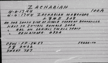
provides
the initial location (CFW_FF-56-57) on a master map for patents issued
before 1756, in what became Carroll, Frederick and Washington
counties. The best image of that map to locate this tract, Zachariah,
is here.
By following his hand drawn coordinates down the side and
across
the top of the map to where they intersect on the map, you find where
Dr. Tracey thought the tract was located in Frederick County.
The
tract tracings on the film, however, do not go up to sheet 757, but stop
with sheet 550.
The film is hard to read and there are often three images of
his
overview maps taken at different light settings, but basically the film
moves from the overview of three counties which is hand drawn
(the best images of which are linked here and here) to the printed
topographical maps with the same handdrawn grid system (the best images
of which are linked here,
here, and here), followed by
an analysis of the early roads beginning here, his
identification of the first
100 surveys in Washington County,
and then detailed tract maps coordinated with his same hand drawn grid
system keyed to county maps, followed by his tract plottings to scale
for tracts.
For example:
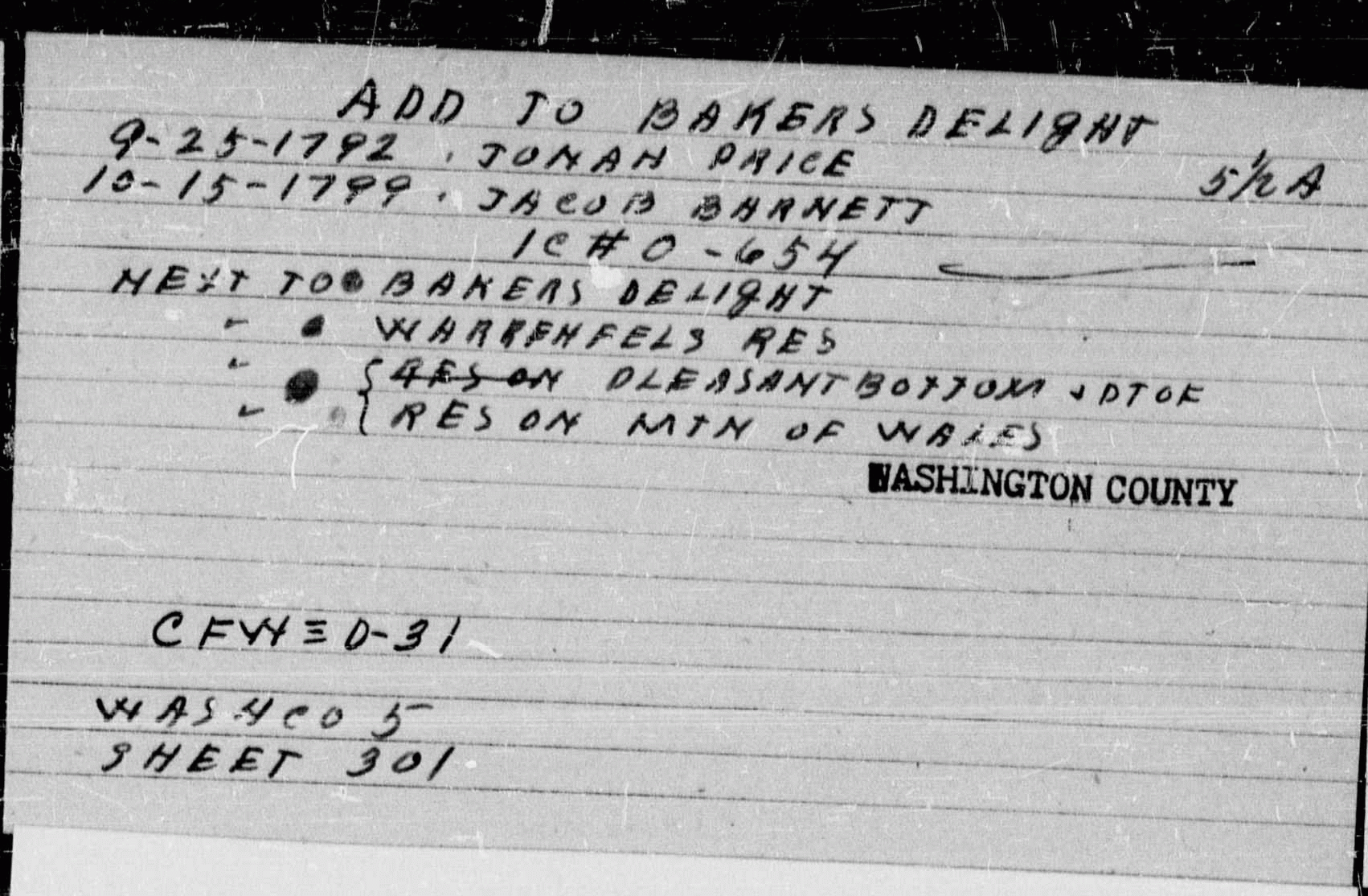
This card refers to "CFW 0-31, WAS CO 5, Sheet 301"
the metes and bounds plotting of which
is to be found here
on the microfilm.
Dr. Tracey explained his index to tracts and his maps as
follows:
Land patents of Carroll,
Frederick and Washington counties -
showing their location on the land - their adjoining tracts –
the relationship one to another - plus other useful information
concerning them.
prepared by
Dr. Arthur G. Tracey
Hampstead, Maryland.
1953
The topographical maps
of Carroll, Frederick and Washington
Counties are divided into blocks one inch square – each square
represents one square mile.
These maps
are lettered down the side and numbered across the
top - beginning with the Northwestern corner of Washington County.
This is the key to the location of the several Land Patents as shown
on each card. (examples: CFW C-3 = the Northwestern corner of
Washington County CFW C 86-87 = the Northeastern corner of Carroll
County).
In the
files of the Land office [now the State Archives] at
Annapolis are envelopes containing Certificates of Survey for the
several Patents to land. These are filed under the name of each
County as Counties were at the time the Survey was made. These files
are indicated on the cards as : E.C.= Baltimore County, F.C.=
Frederick County, P.G.= Prince George's County, and W.C.= Washington
County.
The reel of film containing Dr. Tracey's maps also
includes
the following notation explaining that the maps were filmed in
1974:
Filmed from the records of the
Carroll County Historical
Society
By Paula Dickey, William
Shoemaker, John Frye
December 10, 1974
Copies placed in the
Washington County Court House
Washington County Free
Library
Carroll County
Historical Society